Energy Update



Bhotekoshi Flood: A Wake-Up Call for Stronger Disaster Preparedness
-
 Urja Khabar
- 15 September, 2026
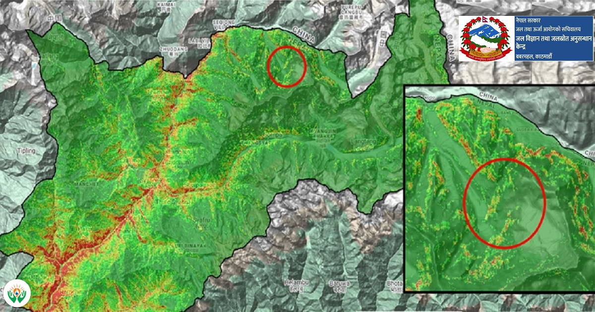
Kathmandu: The devastating flood that swept through the Bhotekoshi–Trishuli–Narayani river system on August 26 was not caused by unusually heavy rainfall, rather it was triggered by a massive high-altitude landslide involving glaciers and rocks, followed by the formation and sudden release of a temporary natural dam, according to a government study.
A report entitled ‘Assessment Report 2 – Rasuwa-Bhotekoshi Flood Event, 2026’, prepared by the Hydrology and Water Resources Research Center under the Secretariat of the Water and Energy Commission, has come up with the findings.

According to the report, the incident was originated around 22 kilometers upstream of the Nepal-China border, where a large section of glacier and rock collapsed in the high Himalayas. Satellite analysis indicates that approximately two square kilometers of glacier and rock were displaced from a steep area between 4,000 and 5,600 meters above sea level.
A glacier located at around 5,200 meters on the northern side of Langtang-Lirung Himal collapsed, sending a massive block of ice and rock down an estimated 1,200 to 2,000 meters. The debris struck a glacier-covered area at around 3,800 meters, generating a powerful mixture of water, ice, rocks and sediment that entered the Chhochen and Lhende rivers before entering into the Bhotekoshi.
22 kilometers in Seven Minutes
The extraordinary speed of the flood was one of the most alarming findings of the study. The flood travelled approximately 22 kilometers from its source to Rasuwagadhi in just seven minutes—an estimated average speed of 188 kilometers per hour.
From Rasuwagadhi to Syaphrubesi, the flood travelled 13.8 kilometers in about 10 minutes, while the 32.2-kilometer stretch from Syaphrubesi to Betrawati was covered in roughly 30 minutes. The flood subsequently reached Devghat after travelling about 201 kilometers from the Nepal-China border in approximately six hours and 42 minutes.
At Devghat, the flood peaked at 6.57 meters, with the maximum discharge estimated at approximately 5,850 cubic meters per second.
Rainfall-Not A Cause
The study found no evidence that rainfall caused the major flood. Satellite estimates recorded less than 10 millimeters of rainfall in and around the affected area during the six hours before 8:45 am on Bhadra 10. At the Cangjing station, only 1.5 millimeters of rainfall was recorded during the six hours before the flood.
However, temperatures had been rising in the Langtang region. The average daily maximum temperature at the Cangjing Snow Station reached 11.78 degree Celsius on August 24. The report recommends further research into whether glacier melting, water infiltration or increased instability of the glacier surface contributed to the event.
Call for Change in Nepal's Forecasting System
A seismic signal recorded at 8:37 am was initially interpreted as a 4.4-magnitude earthquake, which however was identified later by the US Geological Survey as being associated with an avalanche and debris movement.
Following the event, authorities activated the emergency flood-warning system and sent 678,000 SMS alerts through Nepal Telecom and Ncell.
The report warns that rainfall-based forecasting alone is inadequate for sudden Himalayan floods. Nepal now needs an integrated early-warning system combining rainfall, river levels, telemetry, satellite and radar data with glacier, landslide, river-blockage and real-time CCTV monitoring.
The Bhotekoshi disaster, the study concludes, has delivered a stark lesson: in the Himalayas, it is not only water that can rise before a flood—the mountains themselves can move.
Conversation


More News






- Nepal's First Energy Based News Portal
-
Energy Information Center Pvt. Ltd.
Hemant Marg-11, Babar Mahal, Kathmandu
- Info. Dept. Reg. No. : 254/073/74
- Telephone : +977-1-5321303
- Email : [email protected]