 Urja Khabar
After winding through the hilly region of Nepal, the Kosi reaches Chatara at the head of the Tarai plains. Upon traversing Nepal Tarai, it crosses into Bihar and eventually joins the Ganga. In the plains, the Kosi River underwent significant changes in its planform. Over a span of 220 years, from around 1730 to 1950, the river shifted approximately a maximum of 115 kilometers westward in Bihar, In this process, an estimated area of 1,280 square kilometers in Nepal and 15,360 square kilometers in Bihar was affected by frequent flooding and the shifting of the river's various courses. The recurring floods, causing extensive damage, led British Colonial Engineers to dub the Kosi River as "the Sorrow of Bihar."
British engineers initiated efforts to control the changing course and flooding of the Kosi River in the early decades of the 19th century. They contemplated two options: one proposal involved the construction of embankments on both sides of the river, and the other suggested building a high dam in the Barahachhetra gorge in Nepal to store water. However, due to strained relations between the East India Company and the Nepali government at the time, neither of these proposals moved forward.

After the signing of the Sugauli Treaty by the two governments, relations between the two countries began to improve, and the East India Company government initiated correspondence with Nepal on this matter. In 1827. the East India Company government, through the Bengal Irrigation Department, formed a four-member committee to study the nature of floods in the Kosi River and propose measures for its control.
In 1891, the British government sought approval from Nepal to construct embankments with an estimated cost of Rs 15,000 to control the shifting course of the Kosi River. A letter was sent to the Prime Minister of Nepal, seeking approval for the construction of the embankment. The then Nepali Prime Minister, Bir Shamsher, agreed, expressing confidence that the embankments would also provide protection against floods within Nepal. However, in May of the same year, the Kosi area (Nepal-India) witnessed a major flood, underscoring the need to implement control measures. The proposal did not move forward again.
In the Bengal Delta and parts of the Ganga plains, local zamindars (landowners) were already building smaller embankments to meet limited flood control and irrigation needs. They would also break these structures when necessary. Unfortunately, the colonial engineers failed to appreciate the value of local knowledge and practices. British officials prohibited the breaking of these embankments.
In the meantime, the structural approach to flood control by building embankments was already being pursued in the United States. In the 1850s, the United States Congress had approved the construction of embankments along both banks of the Mississippi River for flood control. Subsequently, organizations like the U.S. Army Corps of Engineers and agencies like the Bureau of Reclamation began building embankments along rivers in the United States to control floods.
In the case of rivers in Eastern India, British engineers, however, did not reach an agreement on the specific method of controlling floods. One view leaned towards constructing embankments, while the other favored building a high dam. In flood control-related meetings and conferences, participants discussed the benefits and drawbacks of different methods but did not arrive at a consensus on solutions.
During the Kolkata Flood Conference held on March 14. 1897. the issues of the Kosi River's floods were also discussed. Senior officials of the British government in India participated in the conference, but a definitive resolution on flood control measures for the Kosi could not be reached. Deliberations and debates continued.
Forty years after the Kolkata Conference, in November 1937. another flood conference was held in Patna. During this conference, LE. Hall, the former chief engineer of Bihar, raised questions about the effectiveness of embankments in controlling flooding. He argued. Embankments shift the problem from one place to another. They do not effectively control floods." Similar views had also been expressed in the flood conference held in Odisha, East India, in the 1930s.
In the 1937 Patna Conference, a proposal for constructing a high dam at Barahachhetra was also discussed. Jimut Bahan Sen, the then Secretary of Public Works and Irrigation for Bihar, presented the proposal. Prior to this, a government team, including Sen, had visited the Kosi area.
Four years after the Patna Conference, in 1941, Sir Claud Inglis, the director of the Central Irrigation and Hydrodynamic Research Center of India, visited the Kosi area. He emphasized the need for the study and research on various aspects of the Kosi River. However, his proposal did not gain traction due to the ongoing dynamics of the Second World War.
In 1945, Viceroy Lord Wavell of British India visited the Kosi area. A year later, Ayodhya Nath Khosla, Chairman of the Central Water and Power Commission of India. was assigned the responsibility of preparing the initial design for the dam at Barahachhetra. Specialists such as Dr. J.S. Schavel, Walter Young, and Dr. F.H. Nickells, who were involved in the construction of the Boulder Dam and Grand Coulee Dam in the United States, also provided input to the design.
In addition to the government's efforts, local people also demanded that Kosi floods be controlled. In a conference held on November 16- 17, 1946, in Nirmali, North Bihar, a slogan emerged: "Control the flow, build a dam on the Kosi, and provide electricity to every household."
Following this conference, another meeting was organized in Nirmali in April 1947. in which 60,000 flood victims from the Kosi area participated. In the same year, in August, India gained independence from Britain.
In the April conference, C.H. Bhabha, the Central Energy Minister of India, proposed the construction of a 229-meter-high concrete dam in Barahachhetra. With an installed. capacity of 1200 MW, the proposed project would also provide irrigation services to 1.2 million hectares of land in Bihar. Notable political figures from India, such as Dr. Rajendra Prasad, Dr. Shrikrishna Singh, Rajendra Mishra, Harinath Mishra, and Anugrah Prasad Singh, participated in the Nirmali conference.
After India's independence, discussions and debates continued regarding the proposed measures for controlling the Kosi River. In June 1951, under the chairmanship of an engineer from the West Bengal government, a committee was formed to study the proposed high dam on the Kosi River and its alternatives. However, for various reasons, this proposal did not proceed.
High costs, a strained economic system, and a lack of technical knowledge for constructing a massive concrete dam were identified as limiting factors. Political Considerations also played a role, particularly the competition between Punjab and Bihar over whether to build the Kosi High Dam or the Bhakra Dam in Himachal Pradesh Eventually, the Kosi High Dam was not chosen, and the decision was made to proceed with the Bhakra Dam.
In the discussions related to the control of the Kosi by building embankments or a high dam, there was no participation from Nepal, although some historical documents do mention that Nepal needs to be consulted since Barahachhetra was located in the country. The high dam in Nepali territory, by controlling the Kosi River, would benefit the lower region, mainly Bihar.
In 1953, a massive flood disaster affected North Bihar, prompting the Bihar government to form a committee of experts to study flood control measures. On October 31 and November 1 of the same year, Indian Prime Minister Pandit Jawaharlal Nehru conducted an aerial survey of the flood-affected areas. Witnessing the hardships faced by the flood victims, he suggested that immediate measures be taken to alleviate the hardship. The 1953 flood disaster was caused by a high stage of other rivers, not the Kosi. Still, the construction of embankments along the Kosi River was chosen as the solution, although debates about their long-term effects had not been resolved.
In December 1953, India's Lok Sabha formally approved the Kosi Barrage and Embankment Project. Earlier, the Indian government minister, Mr. Gulzarilal Nanda, had made two statements in the Lok Sabha advocating the project. On April 24, 1954, after the Lok Sabha's approval of the proposal, Minister Nanda arrived in Kathmandu to negotiate an agreement with Nepal. Matrika Prasad Koirala, Prime Minister of Nepal, led the Nepali delegation, and Minister Nanda led the Indian team.
The Indian team had hoped to return on the same day with the agreement signed with the Nepali government, but discussions continued for two days. Forty-two years later, in 1996, government officials of Nepal and India discussed for two days before signing the Integrated Treaty on the Mahakali River.
The 1954 agreement aimed to prevent floods in the lower Kosi River basin. The elements of the treaty included constructing a barrage, protective structures (referred to as embankments) on the two banks of the river, appurtenant works such as afflux and flood banks, and canals. The broad points agreed were as follows:
(a) The barrage will be situated about 3 miles above Hanuman Nagar.
(b) Detailed description of the plan; barrage, general layout, areas within the afflux bund, flood control embankments, and communication lines are provided in the Appendix-1 of the Agreement.
(c) Nepal has the right to use water from the Kosi River for irrigation or any other purpose from time to time as per the need (Nepal), without causing harm to the right of India to manage water in the Kosi River at the barrage site and to produce electricity according to the objectives of the project.
(d) Nepal, through consultations, shall be able to utilize up to 10% of the electricity produced from the powerhouse at the barrage site by making payment to India for the royalty on the tariff fixed for the sale of electricity.
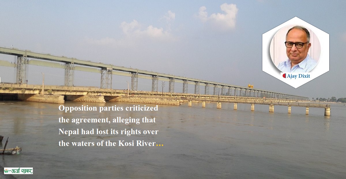
On April 30, 1959, King Mahendra of Nepal laid the foundation stone of the Kosi Barrage. The then Prime Minister of India, Pandit Jawaharlal Nehru, was present at the ceremony. About four years later, the construction of the barrage was completed. On March 31. 1963, the steel doors of the barrage were closed, and two years later, on April 24, 1965, King Mahendra inaugurated the barrage. The then Prime Minister of India, Mr. Lal Bahadur Shastri, was also present at the ceremony. The Kosi project area has been leased to the Government of India by the Government of Nepal for 199 years for operation and management.
The Kosi Agreement led to political controversies in Nepal. Opposition parties criticized the agreement, alleging that Nepal had lost its rights over the waters of the Kosi River. Accusations were also made that the government had sold the river. Mr. B.P. Koirala, the leader of the Nepali Congress, also expressed dissatisfaction with the agreement.
On December 19, 1966, the agreement was amended, and some provisions of the revised agreement are as follows:
- Nepal will have the right to use water from the Kosi or Sun Kosi River basin from time to time for irrigation or other purposes according to the needs. India will have the right to manage water remaining in the river from time to time and to generate electricity in the Eastern Canal, according to the objectives of the project.
In the Kosi Agreement of 1954. there was no mention of irrigation facilities for Nepal. Ten years later, in 1964, India agreed to construct the irrigation project at Chatara to irrigate land in Sunsari and Morang districts. There was no provision to provide irrigation water to Nepal from the Western Kosi Canal, though it was being built through Nepali territory and that the country had been demanding provision to irrigate land in Nepal.
In 1965, Indian Irrigation Minister Dr. K.L. Rao visited Nepal to discuss the Kosi and Gandak projects. During the visit, Minister Rao requested Nepali Irrigation Minister Dr. Nageshwar Prasad Singh to provide land in Saptari District for the construction of the Kosi Western Canal. However, Dr. Singh put forth two conditions. First, the construction of a blacktop road from Kunali to Fattehpur (Saptari) should be ensured. Second, electricity should be supplied to Rajbiraj in Saptari from the Kataya Powerhouse. Dr. Rao accepted these proposals.
On July 7, 1978, representatives of India and Nepal signed the agreement in New Delhi to build the canal from Western Kosi branch canals and the Kosi Pump Canal. Thus the branch canals on the Kosi Western Canal to irrigate 10,000 hectares of land in Nepal's Saptari District and the Kosi Pump Canal systems were constructed.
After the 1954 agreement regarding the Kosi, Nepal and India continued discussions for about 25 years on various aspects related to the barrage and river usage. The initial Kosi agreement had not included some of these elements.
Postscript
After their completion, the embankments have breached eight times in major ways, causing widespread disasters. The 2008 breach at Kusaha was the most devastating. In the meantime, the Kosi High Dam continues to be touted as the panacea for total flood control in Bihar.
In earlier debates, officials within state agencies would express concerns about the high cost of the dam and other associated risks. Today, issues such as the high sedimentation of the proposed reservoir jeopardizing the project's economic viability, the accompanying high social, environmental, and cultural displacements, the risk to the dam in a seismically active region, the larger challenges of flood risk reduction and social vulnerability, rainfall in areas downstream of proposed dam contributing to flooding, including risks due to climate change induced uncertainties, are primarily highlighted by those outside the state agencies.
This article is an adapted version of the section on Kosi from the book Dui Chhimekiko Jalayatra written by Dixit. Now, this is taken from 5th issue of Urja Khabar Semi-annual Journal Publish on 17th December, 2023


.png)